
Maps of Solar Eclipses from 1700 to 1719
The pivotal eclipse broadsides of Edmund Halley for the eclipses of 1715 and 1724 are probably the most famous early eclipse maps because they were widely available to the English public and prepared many people to successfully observe the eclipse of 1715.
In this period in Britain, a broadside was a sheet printed and sold on the streets on a subject of topical or scientific interest. Although many broadsides of Halley’s map were printed, few survive today and command high prices at auction.
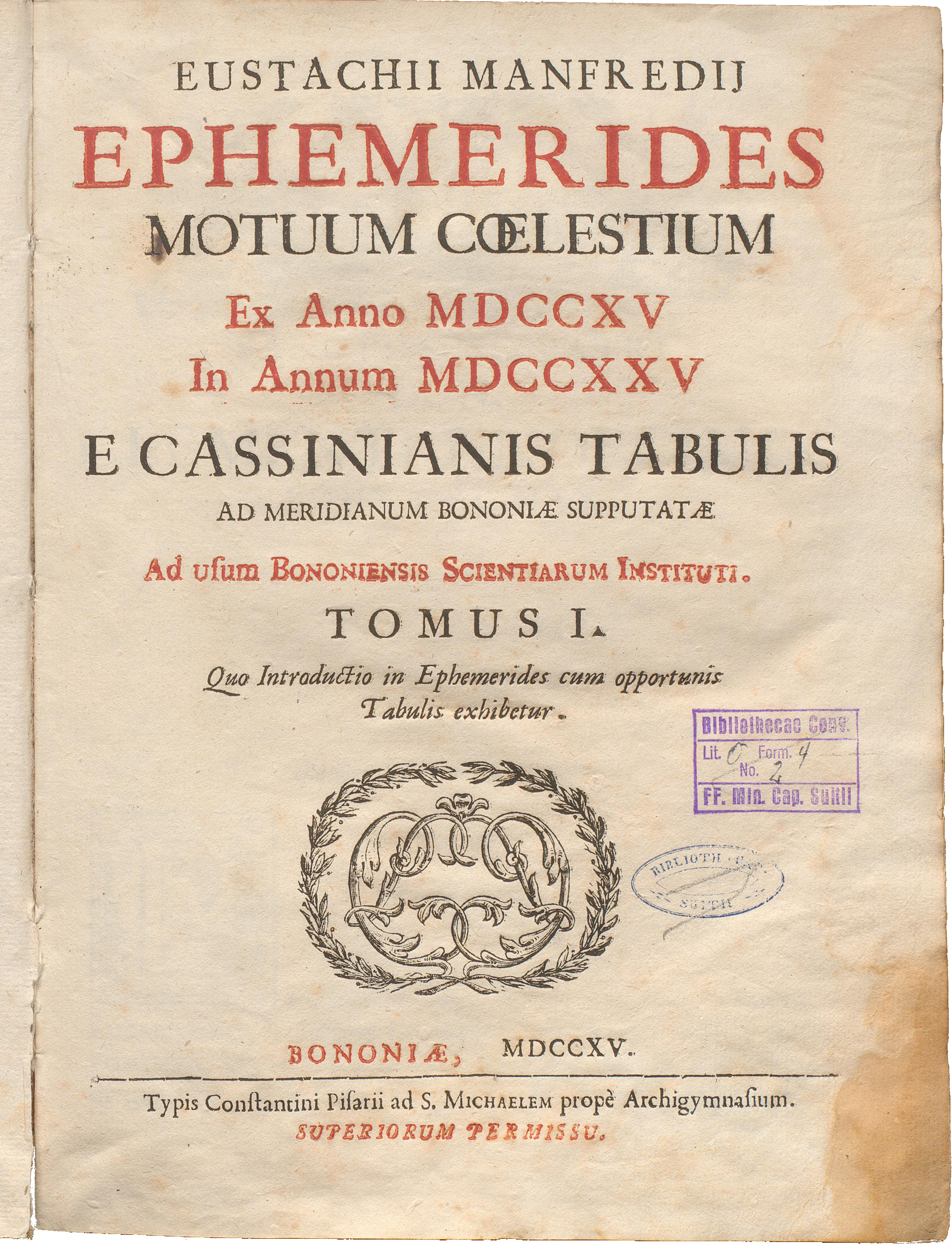
In 1715, an ephemeris was published by Eustachio Manfredi in Italy. Like modern ephermides, tables of planetary motion are given. However, this volume also included a set of early eclipse maps from 1715 to 1725. This was the first ephemeris to contain eclipse maps.
At least three more volumes followed in this Ephemerides series in the remainder of the 18th century. The eclipses which are mapped are those that visit Europe.
Total Solar Eclipse of 1706 May 12
The total solar eclipse of 1706 May 12 cut a diagonal path across Europe from Morocco to Siberia and was widely observed by the public and astronomers of the day such as Cassini and Flamsteed. This eclipse was the subject of at least four eclipse maps of different styles and precision.
In 1707, the cartographer Johann Homann and astronomer Johann Doppelmayr began collaborating on a series of eclipse maps.
This eclipse map of the 1706 eclipse by Johann Homann and Johann Doppelmayr is remarkably detailed and accurate. This is perhaps the first eclipse map to show the umbral path with southern and northern limit lines, marked as “12 zoll”, equivalent to the 12 “digits” (or “doigts”) seen on other early eclipse maps. A good way to judge the accuracy of this map is to inspect the Gibraltar region. The other eclipse curves are marked “11 zoll”, “10 zoll”, “9 zoll”, and so on for the fraction of maximum eclipse outside the zone of totality. The detail in the upper left of the map lists totality duration and maximum eclipse for a number of European cities. Collection of Michael Zeiler.
Johann Doppelmayr and Homann Heirs. Title: Eclipseos Solis Totalis cum mora, d: 12 Maji 1706, horis antem: in Europa celebratae, Geographica Repraesentatio, in qua Centralis Umbrae Tractus ac reliquae Magnitudines suis locis competentes, ex Illustrium Virorum observationibus deductae, per arcus parallelos, ceu digitorum singulorum indices, ope Dni. I. Gabr. Doppelmayer Math: PP curiose oftendentur a Io: Bapt. Homanno
Andreas van Lugtenberg, a teacher of navigation at Rotterdam, published another eclipse map roughly showing the eclipse with two straight lines against a background of the world. This map shows North America with a curious appendage in the northwest.
Andreas van Lugtenberg. Source: National Library of Australia.
This reconstruction of the 1706 Homann & Doppelmayr map shows the southern and northern limit of the path of totality, the first map to do so.
Homann and Heirs published this map of the 1706 total solar eclipse in the Atlas Coelistitis in 1740. This atlas bound 33 large illustrated plates depicting a solar system diagram, charts of constellations, and competing views on the solar system plan by Copernicus, Tycho, and Riccioli.
Johann Doppelmayr and Homann Heirs. 1742, Atlas Novus Coelestis in quo Mundus Spectablis. Title: Theoria Eclipsium in qua variae Solis occultationes, oscurationes Terrae et Lunae verae, stellarum occultationes a Luna aliaq Phaenomena huc Spectantia Sistuntur a Ioh. Gabr: Doppelmaier. Collection of Michael Zeiler.
Symon van de Moolen of Amsterdam was a mathematician with an interest in solar and lunar eclipse calculations. In 1705, he published a 16-page book on the 1706 eclipse which contains the eclipse map below.
Symon van de Moolen, 1705. Courtesy of Robert van Gent.
Total Solar Eclipse of 1715 May 3
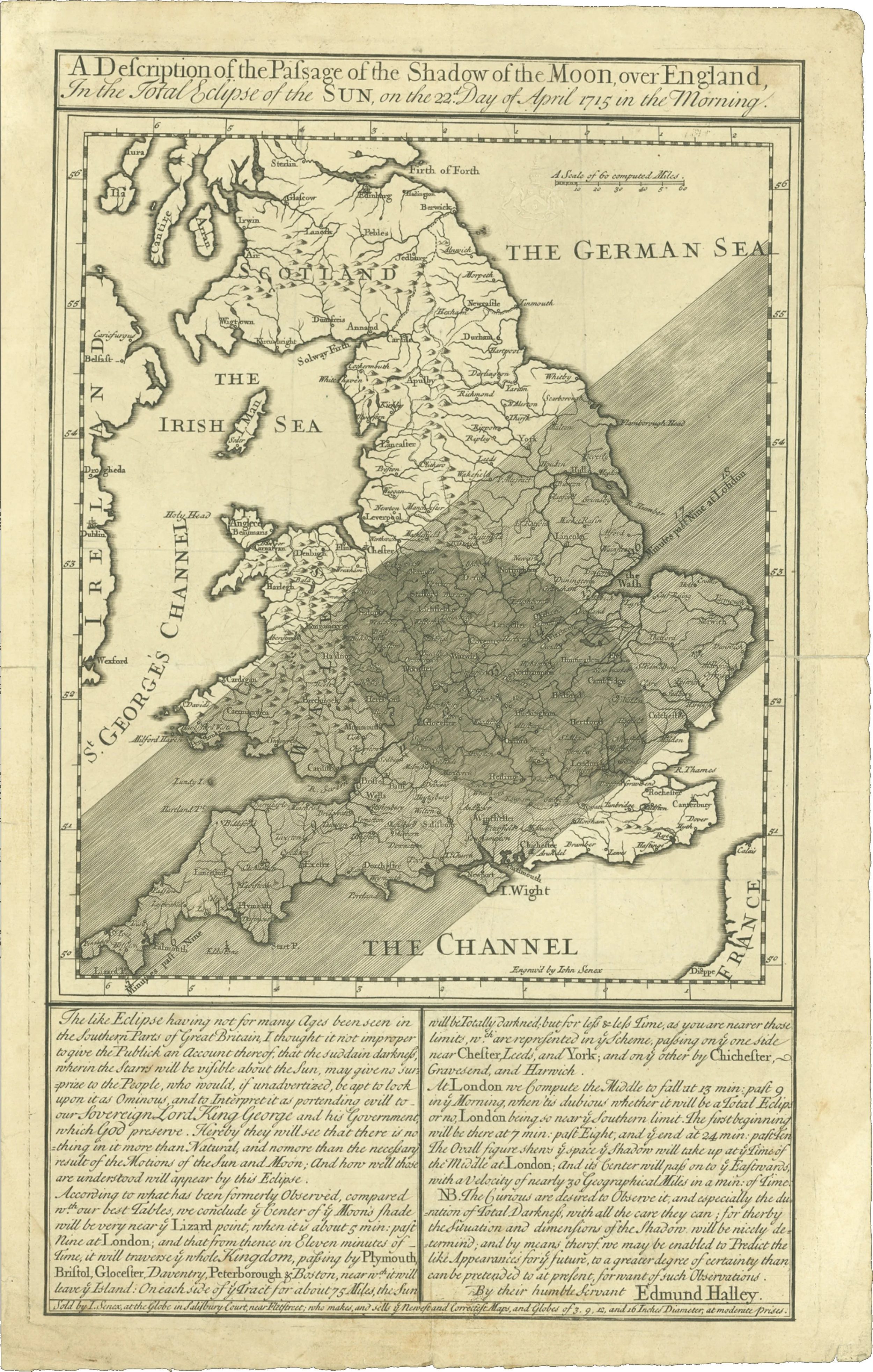
The eclipse maps produced by Edmund Halley for the 1715 and 1724 solar eclipses were breakthroughs in detail and accuracy.
Edmund Halley, 1715. Printed and sold by John Senex. Title: “A Description of the Passage of the Shadow of the Moon over England, In The Total Eclipse of the Sun, on the 22nd Day of April 1715 in the Morning.”
Besides the new level of accuracy in eclipse predictions, there are two interesting innovations in Edmund Halley’s 1715 eclipse map.
The first innovation is the umbral oval within the map that gives the map reader a picture of the umbra as a shadow intersecting the earth at a moment in time. From this oval, the map reader understands that the shadow is sweeping along the path of totality. The oval is an interesting map feature that combines the geographic context with the temporal dimension of the eclipse and gives the map a sense of dynamism.
The other innovation is Halley’s invitation for eclipse observations, shown in the detail above. Halley did receive reports from many parts of southern England which he applied to create a revised map with improved eclipse lines. This is akin to today’s social networking technology and makes this map participatory instead of a one-way broadcast of information.
Following the original map of the 1715 solar eclipse, Halley published an updated map which incorporated observations from which places were in shadow and which places were outside. This allowed a visible refinement of the 1715 eclipse path from the original.
In the description, Halley notes that Plymouth, Exeter, Buckingham, and Huntingdon were close to the center line of the eclipse. Cities which also witnessed totality were Bath, Lynn, Oxford, and Ely.
This map also has a prediction of the path of the 1724 total solar eclipse crossing from Ireland to France.

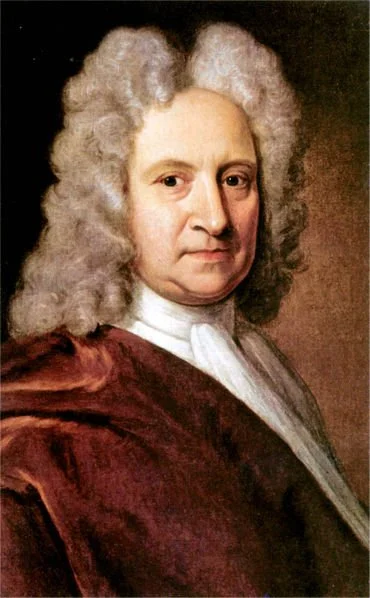
Edmund Halley, painting by Richard Phillips. Source: commons.wikimedia.org/wiki/File:Edmond_Halley_072_old_version.jpg
1715 April 22 TSE & 1724 May 11 TSE, Edmund Halley, University of Cambridge http://www.dspace.cam.ac.uk
In Halley’s words, this was the motivation for his eclipse maps:
The Novelty of the thing being likely to excite a general Curiosity, and having found, by comparing what had been formerly observed of Solar Eclipses, that the whole Shadow would fall upon England, I thought it a very proper opportunity to ge the Dimensions of the Shade ascertained by observation; and accordingly I caused small Map of England, describing the Track and Bounds thereof, to be dispersed all over the Kingdom, with a Request to the Curious to observe what they could about it, but more especially to note the Time of Continuance of total Darkness, as requiring no other Instrument than a Pendulum Clock with which most Persons furnish'd, and as being determinable with the utmost Exactness, by reason of the momentaneous Occultation and Emersion of the luminous Edge of the Sun, whose least part makes Day.
Johannes Gaupp was a student of Erhard Weigel, creator of the first 1654 eclipse map. His map of the 1715 eclipse is based on the astronomical tables of the French astronomer Philippe de la Hire. This treatise is “Ausführliche Beschreibung Der grossen Son[n]en Finsternuss welche Anno M. DCC. XV den 3. May vormittag in gantz Europa und zum Theil auch ausserdemselbigen zu sehen seyn wird…”
Johannes Gaupp Title: “EUROPA d. 3. Maij. Ao 1715. ECLIPSANDA ex Calculo secondum Tabb. Astronomicas Dr. Phil. de la Hire e Soc. Reg. Paris geographic delineata a I.G.”, Source: https://gallica.bnf.fr/ark:/12148/btv1b26002037.r=Johannes%20Gaupp?rk=21459;2
Eustachio Manfredi, Title: Typus obscurationis telluris in eclipse Solis die 2 Mai Source: https://nla.gov.au/nla.obj-232372622/view
William Whiston was an English scientist and a student of Isaac Newton. He published this calculation of the eclipse showing the geometry of the Moon’s shadow in passage across the Earth. Unfortunately, the globe does not have any geographic features, limiting the utility of this early eclipse map.
William Whiston Title: “A Calculation of the Great Eclipse of the Sun , April 22d. 1715 in ye Morning, from Mr. Flamsteed's Tables, as corrected according to Sr. Isaac Newton's Theory of ye Moon in ye Astronomical Lectures; with its Construction for London Rome and Stockholme. By W: Whiston M.A.”, Source: University of Cambridge http://www.dspace.cam.ac.uk
In 1715, Eustachio Manfredi published the first of several volumes of the Ephemerides Motuum Coelestium (Tables of Celestial Motion). These were the first ephemerides to include maps of coming solar eclipses.
The first volume spanned the years 1715 to 1725. Successive volumes spanned the years 1726 to 1737 and 1738 to 1750.
Partial Solar Eclipse of 1718 March 2
Johannes Gaupp, student of Erhard Weigel and contemporary of Johann Gabriel Doppelmayr, published a pocket almanac “Calendarium novum astronomicum ad annum a nat. D. N. J. Ch. 1718”. This almanac contains an early eclipse map of the partial solar eclipse of 1718 March 2.
Johannes Gaupp, Title: “Typus Obscurationis Telluris in Eclipso Solis d. 2. Martin Ao 1718.” Source: https://daten.digitale-sammlungen.de/0000/bsb00001361/images/index.html?fip=193.174.98.30&id=00001361&seite=80
